


Tuntutuliak Precinct, Bethel Census Area, Alaska
About
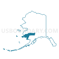
Outline

Summary
| Unique Area Identifier | 523273 |
| Name | Tuntutuliak Precinct |
| County | Bethel Census Area |
| State | Alaska |
| Area (square miles) | 523.23 |
| Land Area (square miles) | 353.93 |
| Water Area (square miles) | 169.30 |
| % of Land Area | 67.64 |
| % of Water Area | 32.36 |
| Latitude of the Internal Point | 60.12604270 |
| Longtitude of the Internal Point | -162.66765640 |
Maps


Graphs
Select a template below for downloading or customizing gragh for Tuntutuliak Precinct, Bethel Census Area, Alaska


Neighbors
Neighoring Voting District (by Name) Neighboring Voting District on the Map
- Chefornak Precinct, Bethel Census Area, AK
- Eek Precinct, Bethel Census Area, AK
- Kasigluk Precinct, Bethel Census Area, AK
- Kongiganak Precinct, Bethel Census Area, AK
- Napaskiak Precinct, Bethel Census Area, AK
- Quinhagak Precinct, Bethel Census Area, AK